
Products
Improve Your Field Services with LemurTM

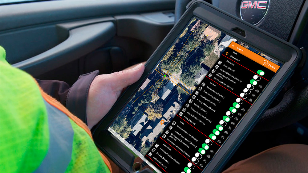
Modern mobile mapping that also works offline
Bring the power of geospatial technology to field workers. Lemur provides users zero-training access to your existing GIS. Staff can use geospatial workflows like redlining and as-builting to improve both field and back-office business processes.
Lemur is purpose built to work offline, so staff can perform remote duties regardless of cell coverage. By delivering an intuitive, robust geospatial toolset, Lemur reduces time wasted finding information, improves safety, and increases field efficiency.
Lemur benefits
Lemur can save 3-5% on field service costs by reducing overhead, errors, and waste. Organizations can leverage the mobile GIS solution to:
Perform work in both online and offline environments
Accelerate construction to as-built in record time
Capture and correct data in the field
Reduce errors in performing and recording work
Ensure adoption and minimize training
Enterprise-grade mobile software
With Lemur, you add the benefits of powerful GIS tools to sophisticated work management, assignment, tracking, and other capabilities of your field service solution. Lemur complements your organization’s field service solution with world-class geospatial capabilities that no standalone field service app delivers. Lemur’s unique connectors to field service apps make field workflows powerful and intuitive.
Lemur supports a wide array of field operations, from vegetation management to asset maintenance and construction. It provides security that includes encrypted communication and authentication, as well as central control over access of critical infrastructure data.

Lemur – modern mobile mapping
Discover the benefits of bringing GIS and other enterprise apps to the field and back office. Locana’s Lemur mobile mapping solution seamlessly delivers integrated, intuitive tools for work order management, asset management, and more. Staff can easily collect data and document work in a safe, efficient, and accurate manner.
Lemur is Veracode Verified
Veracode Verified Standard represents that the following application security practices are embedded into the software development process:
- Assessment of first-party code using static analysis
- Documentation that the application does not allow Very High flaws in its first-party code
- Developer access to remediation guidance Verified Standard is the first of three (3) tiers representing the Verified program
Learn more about the Veracode Verified program by clicking here.
Why Lemur
Whether you’re online or offline, experience all of these capabilities in a blazing fast map experience anywhere you work.
![]()
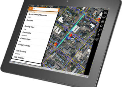
Locate correct assets quickly
![]()
Understand asset connectivity and interdependence
![]()
Look up asset characteristics
![]()
Record work and defect locations
![]()
Sketch, redline, markup, and quickly create clear as-built drawings
Learn more

Avoid the Point Solution Complexity Trap in Field Programs

Gain Exceptional Performance, Speed, and Usability with Lemur Mobile Mapping
Transform Your Field Service With Modern Mobile Mapping

Modernize Your Field Services with GIS and Work Order Management Combined
Lemur was a game-changer for our field users. They no longer required online access, and because the data is cached on the iPad, the speed of a map is incredible. So you have your functionality and data available when you need it.
Let’s Connect
Want to learn more about Locana? Visit our services and industries pages.

At Locana, we believe maps and location intelligence can help solve the most pressing infrastructure, sustainability, social, and business challenges.
At Locana, we believe maps and location intelligence can help solve the most pressing infrastructure, sustainability, social, and business challenges.
Locations
United Kingdom
© 2024 Locana